


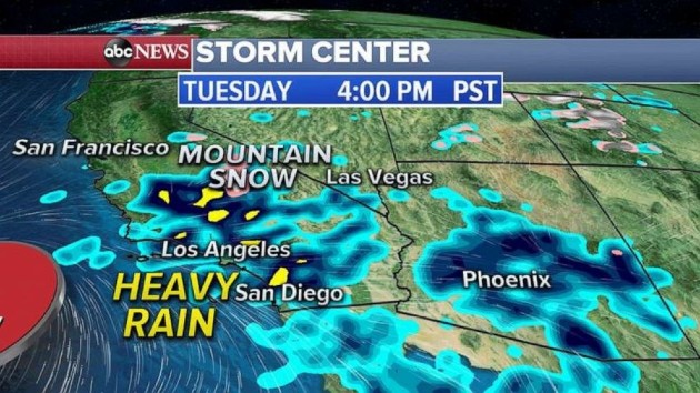
ABC News(NEW YORK) — An active storm pattern is moving across the country with several systems that will bring heavy rain, strong thunderstorms, mountain snow and even a threat for flash flooding to southern California. On Monday morning, we are watching three storm systems, one of which has already brought heavy snow to the West from California to Nevada and into Idaho where some areas already got up to 8 inches of snow. This storm system has moved out into the Plains and the Midwest and will be bringing showers and thunderstorms to the area Monday. Two more storm systems are moving into the West Coast Monday, one in the northern Rockies and another one for southern California and the Southwest. Let’s concentrate on that second western storm that will move into southern California Monday night with heavy rain, thunderstorms and a threat for flash flooding and even mudslides. Some of the rain will also move into Arizona and the deserts where some flash flooding is possible.By Wednesday, the Southwest should continue to see heavy rain and a threat for flash flooding. Meanwhile, the northern Rockies storm system will quickly move into the South and bring strong thunderstorms with damaging winds and heavy rain. In southern California, locally 2 to 3 inches of rain is possible with higher elevations getting up to a foot of snow. Locally, more than 3 inches of rain is possible in the South and about 2 inches of rain is expected in the Midwest and parts of the Great Lakes.Elsewhere, the warmest temperature of the year so far happened Sunday in Chicago when the city reached 67 degrees. Also, in the Twin Cities, temperatures reaches 61 degrees which was also the warmest temperature of the year. On Monday, the warmth moves east with highs near 70 degrees in Washington, D.C., New York City and Boston.Copyright © 2020, ABC Audio. All rights reserved.

