


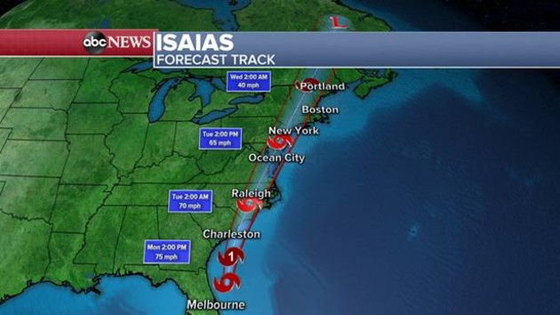
ABC NewsBy EMILY SHAPIRO and DANIEL MANZO, ABC News(NEW YORK) — Officials in Florida are already closing off several major areas, including beaches, parks and testing sites for COVID-19.Tropical Storm Isaias is expected to strengthen to a Category 1 hurricane as it approaches northeastern South Carolina and southern North Carolina on Monday.Hurricane warnings have been issued for parts of the Carolinas and tropical storm alerts stretch from Florida to New England. Isaias is forecast to bring torrential rain, flash flooding and storm surge.As Isaias approaches the Carolinas, storm surge may reach 5 feet, especially near the South Carolina-North Carolina border. Tornadoes are also possible in the Carolinas.North Carolina Gov. Roy Cooper declared a state of emergency on Friday.Evacuations have been ordered for Hatteras and Ocracoke Islands, Ocean Isle Beach, Holden Beach and Caswell Beach.Bo Bramlett looks at the ocean on the morning of Aug. 3, 2020 in Myrtle Beach, S.C., as Tropical Storm Isaias continued to move north along the eastern United States.Waves driven by Tropical Storm Isaias crash over the jetty on the north side of the Palm Beach Inlet in Palm Beach Shores, Aug. 2, 2020.After landfall in the Carolinas, Isaias will weaken and race up the East Coast.Isaias will reach the Mid-Atlantic by early morning Tuesday and the Northeast by Tuesday night.Over six inches of rain are forecast for the Mid-Atlantic.The heaviest rainfall is expected to hit along the Interstate 95 corridor from Washington, D.C., to Philadelphia to New York City.New York City is expected to get hit by tropical-storm force winds, storm surge and several inches of rain, city officials said.Lower Manhattan is particularly vulnerable to storm surge, New York City Mayor Bill de Blasio said Monday. Emergency management crews are deploying flood protection measures, he said.”We are not taking any chances at all,” de Blasio said. Copyright © 2020, ABC Audio. All rights reserved.

