


By DANIEL MANZO and DAN PECK, ABC NEWS
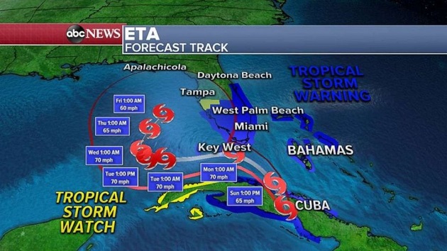
(NEW YORK) — South Florida is starting to see the effects from Tropical Storm Eta after it made landfall early Sunday morning along the coast of Cuba with winds of 65 mph.The last named storm to make landfall in Cuba during November was Paloma in 2008.The center of Eta is about 40 miles east of Marathon and moving northwest at 14 mph.It made landfall on Lower Matecumbe Key in the Florida Keys Sunday night, according to Doppler radar data, and will continue to move along the Keys with strong, gusty winds and bands of heavy rain extending up across portions of South Florida.Relentless bands of heavy rain have been battering eastern Broward County since Sunday evening. There is a flash flood warning in effect there and in Fort Lauderdale. Eta is expected to travel west of the Keys by Monday morning.Over half a foot of rain has already fallen in parts of eastern Broward County and significant flash flooding has been reported from Hollywood to Fort Lauderdale. More rain and wind is expected throughout the night, into Monday.Eta is expected to strengthen slightly overnight, but it is no longer forecast to reach hurricane strength while it hits the Florida Keys. Still, the hurricane warning will remain in effect across the Keys until at least Monday.
A tropical storm warning is in effect across South Florida, including Miami, Fort Myers, Naples and West Palm Beach. A hurricane and storm surge warning is in effect across the Florida Keys.Storm surges of up to 4 feet will be possible in parts of southern Florida.
As Eta closes in on Florida, heavy rain and gusty winds will become more widespread by the evening hours.It will then slow down and meander over the southeastern Gulf of Mexico Tuesday into Wednesday.Additionally, there could be tornadoes as Eta moves through Florida over the next 48 hours.Forecast models actually have Eta stalling in the Gulf of Mexico through much of the upcoming week.There is potential that cold fronts moving across parts of the eastern U.S. could draw tropical moisture from Eta, creating a potential for flash flooding in some spots along the East Coast later this week.In the west, a storm system is beginning to move across part of the country, bringing snow, rain and some gusty winds.Some of the most organized areas of snow were in parts of Montana and the Rocky Mountains, where up to 3 feet is expected through Tuesday.This storm system and its associated dip in the jet stream is expected to bring wind gusts locally over 50 mph from California all the way to Wisconsin.Elsewhere, Los Angeles received 0.11 inches of rain on Saturday, ending a 172-day streak of no rain.Copyright © 2020, ABC Audio. All rights reserved.

