


BY: DANIEL MANZO and DAN PECK, ABC NEWS
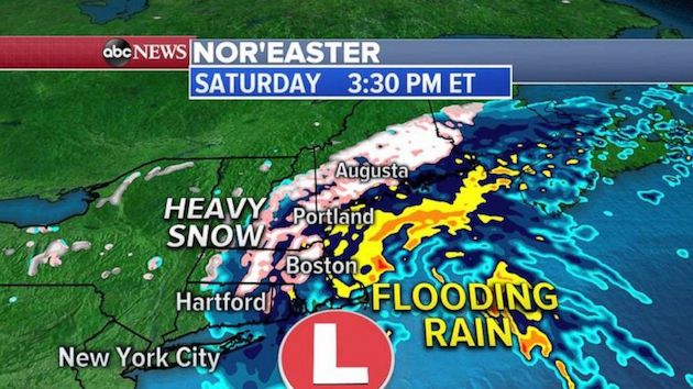
(NEW YORK) —A storm system is bringing heavy snow across parts of New England. So far, 6 inches of snow has been reported in Worchester, Massachussettes, with 2-3 inches reported across portions of northeastern Connecticut.Winds are also increasing along the southeastern New England coast with gusts over 40 mph reported recently in New London, Connecticut, and Cape Cod, Massachussettes.Heavy snow is now falling from Connecticut up to Maine with heavy rain and strong, gusty winds developing along the coast.The precipitation will continue through the afternoon and evening hours with most of the rain along the coast changing to a heavy/wet snow by this evening as the storm moves northeast parallel off the New England coast into tonight.The heavy snow and gusty winds will lead to tree damage, power outages and impact travel across parts of the region. Snowfall rates of 1-2 inches per hours is possible over the next several hours along with thundersnow.Up to 1 inch per hour of heavy rain was reported in parts of Maryland and Delaware Saturday morning. There has also been some flooding.The heaviest rain is expected to pivot into some of the northeastern cities throughout the morning, and winds are expected to increase as well, gusting, at times, at over 30 mph.A winter weather advisory is in effect for Hartford, Connecticut and Plymouth, Massachusettes.Wind alerts are also in effect along the New England coast and extend to Suffolk County, New York, on Long Island. The strongest winds will occur on Cape Cod where a high wind warning is in effect. Gusts of 50-60 mph are possible there.The good news is that this is a fairly quick-moving storm. By later tonight the storm will be over for most of New England, lingering across Maine during the early morning hours tomorrow bringing more snow and gusty winds.Behind this storm, cold air will settle in across the Northeast and stick around through early next week. On Monday morning, wind chills will be in the teens across much of the region and dip down into the lower 20s along the I-95 corridor.Through tomorrow morning, accumulating snow is expected across much of New England with the biggest totals forecast from east-central Massachusettes up through eastern New Hampshire into Maine. In these areas a widespread 6-10 inches-plus of snow will fall.Some areas could see over a foot of snow, especially up across Maine through tonight. Several inches of snow is forecast in the Boston metro area, however snow totals will be lower along the coast and higher inland.In southern California, the current fire danger continues to subside across much of the region, however, gusty winds and dry conditions will persist in some areas through this evening. A red flag warning remains in effect across the LA/Ventura County mountains and the Santa Clarita Valley until 10 p.m. PT.The Bond Fire is now at 7,375 acres with containment up to 40%. There will be improved conditions across the region on Sunday ahead of the next Santa Ana wind event and may pose new fire danger for Monday into Tuesday of the upcoming week.Fire weather watches have been posted across much of southern California, including Los Angeles, with another round of strong winds and very dry conditions bringing critical fire weather conditions to the region. Winds will increase throughout the day on Monday and remain strong into Tuesday morning.Sunday will be relatively calm in terms of wind across Southern California.Another Santa Ana wind event will arrive Monday or Tuesday. It’s unclear how low the relative humidity will be, but regardless, there will likely be a period of enhanced fire conditions.Copyright © 2020, ABC Audio. All rights reserved.

