


(NEW YORK) — A storm, for once, isn’t going to move cross-country this week, however, near-record-breaking temperatures will.
A major warming trend is expected to move across much of the country in the next few days, with temperatures coming in close to normal for the first half of the week but forecast to soar to summertime levels by Thursday and Friday.
Phoenix is expected to hit the high 90s this week, with Tuesday reaching 99 degrees and Las Vegas will reach 90 degrees on Monday.
Temperatures in Denver will hit the mid-80s on Tuesday and Wednesday. Billings, Montana, will reach 82 degrees on Tuesday, before an expected nearly 30-degree drop the following day, where the temperature is forecast to reach 55 degrees.
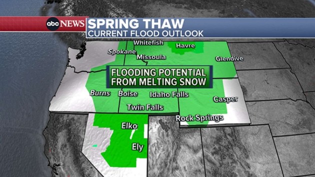
Meanwhile, a series of storms moving onshore in the Pacific Northwest will be dropping more rainfall.
As that storm moves eastward, the rainfall combined with above-normal temperatures will be melting much of the thick snowpack, which could contribute to flooding issues from Montana to Nevada throughout the week, with many rivers west of the continental divide likely seeing an abundance of water due to snow melt in the coming weeks.
Dozens of record-high temperatures may break across the East Coast, with cities like Philadelphia, New York and Boston heading into the 70s and 80s.
Philadelphia will reach 80 and 84 degrees on Wednesday and Thursday, respectively.
New York City is expected to reach 75 degrees on Wednesday, 77 on Thursday and 79 degrees on Friday.
Syracuse, New York, is forecast to hit a high of 84 degrees on Friday, while temperatures in Manchester, New Hampshire, will reach 81 degrees.
Last month, much of upstate New York and New Hampshire received heavy snow, with more than 2 feet of snow falling in several regions along the East Coast because of a nor’easter in March.
Copyright © 2023, ABC Audio. All rights reserved.

