


(NEW YORK) — Hurricane Lee, which is crawling through the Atlantic Ocean as a major Category 3 storm, is bringing dangerous rip currents and huge waves to the East Coast.
Here’s what you need to know:
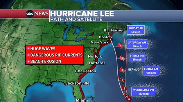
Alerts for high surf and rip currents have been issued from Florida to Massachusetts.
On Wednesday, the Carolinas will see waves reaching 8 to 12 feet. New Jersey and Long Island are forecast to get 7- to 10-foot waves.
New York Gov. Kathy Hochul is sending 50 National Guardsmen to help Long Island prepare for the possible high surf, rip currents, coastal flooding and beach erosion.
“Out of an abundance of caution, I have deployed the National Guard and directed state agencies to prepare emergency response assets and be ready to respond to local requests for assistance,” Hochul said in a statement on Tuesday.
By Thursday night, Lee will start to move north and weaken. It’s forecast to pass Bermuda as a Category 1 hurricane, bringing gusty winds and rain squalls. A tropical storm warning has been issued for the island.
Lee is forecast to still be hurricane-strength by the time it passes east of Cape Cod, Massachusetts, over the weekend.
By Saturday morning, Lee is expected to bring strong, gusty winds to coastal New England, from Rhode Island to Boston to Maine. The strong winds will last through the day on Saturday.
On Saturday evening, Lee may make landfall between coastal Maine and Nova Scotia, bringing huge waves, heavy rain, storm surge and powerful winds.
Rain is forecast from Cape Cod to Maine, with the heaviest rain and worst storm surge in Maine.
Copyright © 2023, ABC Audio. All rights reserved.

