


(NEW YORK) — Hurricane Lee, which is crawling through the Atlantic Ocean as a major Category 3 storm, will slowly start to turn north and move parallel to the eastern United States this week.
As of 10 a.m. ET on Tuesday, Lee was located about 555 miles south of Bermuda, moving at 6 mph with maximum sustained winds of 115 mph, according to the National Hurricane Center.
“Some slow weakening is forecast during the next 48 hours, but Lee is expected to remain a large and powerful hurricane,” the National Hurricane Center warned.
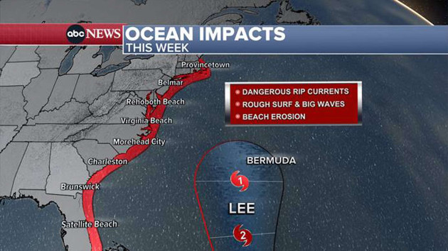
The latest track shows Lee will move north and pass very close to Bermuda on Friday morning, bringing huge waves, gusty winds and some rain to the British island territory.
A tropical storm watch was issued Tuesday morning for Bermuda.
By Saturday morning, Lee will barely be a hurricane as it moves parallel to the East Coast, spreading large waves from the Jersey Shore to Maine.
On Saturday evening, Lee will begin to approach New England, potentially bringing some gusty winds and rain.
Dangerous rip currents, rough surf, huge waves and beach erosion will be possible all week long and into this weekend for the East Coast.
Large waves were already affecting the northern Caribbean, the Bahamas, Florida and the Carolinas on Tuesday morning. The waves will reach New Jersey and Long Island by Wednesday morning.
American and European spaghetti models currently disagree on where Lee will make landfall. The European model projects landfall somewhere along Maine’s coast over the weekend, with plenty of wind and rain for Portland, Boston and coastal New England. Meanwhile, the American model projects landfall in Nova Scotia on Sunday morning, with less wind and rain for coastal New England.
The forecast could change in the coming hours and days.
Copyright © 2023, ABC Audio. All rights reserved.

