


(NEW YORK) — Hurricane Ian developed into the monstrous, devastating storm meteorologists predicted it would be.
Ian barreled into the southwest coast of Florida as a major Category 4 hurricane before slowing to a crawl as it made its way across the peninsula, causing widespread destruction in its wake.
The storm will come to be known as “The Big One” in the Fort Myers area, Florida Gov. Ron DeSantis told reporters in a news conference Wednesday as the hurricane continued its damage.
“The impacts of this storm are historic and the damage that was done has been historic,” DeSantis said Thursday morning in his first address since the damage assessments in the southwest portion of the state began. “I think we’ve never seen a flood event like this, we’ve never seen storm surge of this magnitude, and it hit an area where there’s a lot of people in a lot of those low lying areas.”
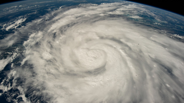
When Ian made landfall near Cayo Costa, an island off the coast of Fort Myers, just after 3 p.m. on Wednesday, it brought 150 mph winds — tying as the fifth-strongest hurricane to make landfall in the U.S., according to the National Hurricane Center.
Ian then made a second landfall 90 minutes later, still as a Category 4 storm with 145 mph winds, just south of Punta Gorda, near Pirate Harbor.
The devastating wind gusts were widespread throughout the state.
Cape Coral saw winds at 140 mph, Port Charlotte at 132 mph, and Redfish Pass at 126 mph. In Tampa, about 100 miles away from the center of the storm as it made landfall, wind gusts topped 75 mph.
Early Thursday, more than 2.3 million customers in the state were without power. In Lee County, nearly all residents were without power, emergency officials announced Thursday.
Storm surge records were set for both Fort Myers at 7 feet, and Naples, at 6 feet and rising, with locals reporting houses and cars floating in the influx of water.
Rainfall in Orlando broke its 24-hour rainfall record with 12.49 inches. By Friday, New Smyrna Beach was swamped with 28.60 inches of rain in just 27 hours.
Other significant totals included Union Park, at 16.69 inches and Lake Mary, at 16.14 inches.
Flash flood emergencies were reported at Daytona Beach, New Smyrna Beach and the Ponce Inlet, where numerous water rescues were conducted.
In Orlando, more than 250 water rescues were conducted as a result of the inland flooding, Orlando Mayor Buddy Dyer announced Thursday. Reports for multiple fatalities in Charlotte and Volusia Counties were announced Thursday as well.
The hurricane was so severe and far-reaching it caused a ripple effect of more than 2,000 flight cancellations on Wednesday. Widespread cancellations continued into Thursday as the storm system pushed along its path of destruction.
After three landfalls — one in Cuba and two in Florida — Ian is expected to make a fourth landfall as a Category 1 hurricane on the South Carolina coast between Charleston and Myrtle Beach after 2 p.m. ET on Friday, with winds reaching 85 mph.
After Ian exits into the Atlantic Ocean near Jacksonville as a tropical storm, it is expected to strengthen and be pushed back onto land along the South Carolina coast.
A hurricane warning was issued for the entire coast on Thursday morning, with storm surge on both the South Carolina and Georgia coasts. A hurricane watch has been issued for southern part of North Carolina.
In some areas, storm surge could be as high as 7 feet, according to the National Hurricane Center. The all-time record for storm surge in South Carolina is 9 feet, based on data from the National Hurricane Center.
The destruction from the monstrous storm is expected to continue into Friday.
Copyright © 2022, ABC Audio. All rights reserved.

