


(NEW YORK) — More than 105 million Americans remain on alert for dangerously low wind chills after an artic blast swept across the United States.
There were at least nine weather-related fatalities nationwide this week — six in Tennessee, two in New Jersey and one in Mississippi, according to authorities.
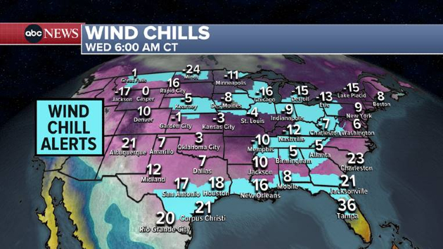
As of early Wednesday, the National Weather Service had wind chill advisories or warnings in effect for 26 states, from North Dakota to Florida.
The wind chill — what temperature it feels like — was forecast to be -25 degrees Fahrenheit in parts of North Dakota on Wednesday morning, -16 in Chicago, Illinois, and -12 in Nashville, Tennessee.
Some of the coldest temperatures of the season were headed to the Northeast, with Wednesday morning’s wind chills expected to be in the single digits along the Interstate 95 travel corridor, though no alerts have been issued.
Typically warm Tampa, Florida, was also under a wind chill advisory on Wednesday morning as feels-like temperatures may reach near 20 degrees.
Meanwhile, Austin and San Antonio, Texas, could break daily records for low temperatures on Wednesday at or around 10 degrees.
In the coming days, wind chills on Saturday morning will reach -22 degrees in Kansas City and go below zero in Memphis, Tennessee. Morning wind chills in Chicago will remain below zero through the weekend.
Although conditions will be dry in the Northeast on Wednesday, areas around the Great Lakes were expected to get more snow. Lake-effect snow warnings were in effect for places like Buffalo and Watertown, New York, where the snowfall could amass to 4 feet by Thursday evening. That’s on top of the more than 40 inches of snow that fell over last weekend.
Another storm was already coming ashore in the Pacific Northwest on Wednesday morning. Ice storm warnings were in effect for more than three million people in Oregon, including Portland where residents could wake up to as much as 3/4 inches of ice. More than 65,000 customers in Oregon were without power as of 4:30 a.m. ET.
In the Cascade mountain range, there was a chance for up to 7 inches of snow and 1 inch of ice.
The snow from this storm will move over the Rocky Mountains on Wednesday and Thursday, including in Colorado where avalanche warnings were in effect through Thursday. The avalanche danger is high — at a level 4 out of 5 — because heavy snow and strong winds have created very treacherous conditions that could easily trigger large and dangerous avalanches.
High wind warnings were also in effect for parts of Colorado’s mountains, with winds up to 75 miles per hour possible on Wednesday morning.
Colorado’s Rockies could get as much as 2 feet of snow from Wednesday morning to Friday morning. The snowfall will then move in to Nebraska and Missouri on Thursday.
A separate weather system will bring snow to Kentucky on Thursday before combining with the moisture from the Plains to bring another round of snow to the Northeast on Friday, with an additional 1 to 3 inches in the forecast for the I-95 corridor.
Copyright © 2024, ABC Audio. All rights reserved.

