


(NEW YORK) — Multiple people have been injured and significant damage has been reported in Florida due to a possible tornado as part of a major storm system expected to bring severe weather to parts of the East Coast on Tuesday.
At least 10 tornadoes have been reported in Texas, Florida and Alabama since Monday, most occurring overnight and Tuesday morning in Florida’s Panhandle, as the major storm crosses the country.
A tornado hit the Panama City area in Bay County early Tuesday, according to the National Weather Service.
At least five people in the county were transported to hospitals with injuries, Bay County spokesperson Valerie Sale told ABC News. There are also reports of significant damage throughout the county due to the storm, Sale said.
Florida Gov. Ron DeSantis has issued a state of emergency for northern Florida due to the severe weather threat. The order covers 49 counties in north and central Florida.
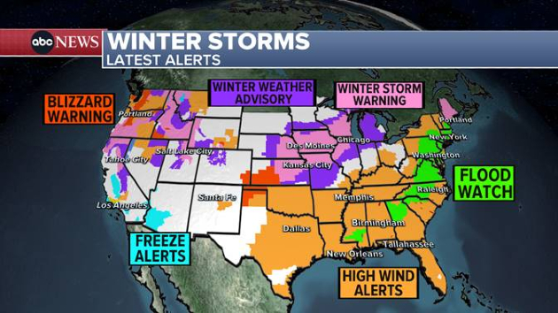
The storm system is expected to swing north and bring flooding and damaging winds to the Northeast later Tuesday.
There are currently 13 states on flood watch from Georgia to Maine as the storm approaches the East Coast, with severe weather for the Carolinas, Florida and Georgia with tornadoes and flash flooding possible Tuesday.
Heavy rain will arrive in the Mid-Atlantic by around noon on Tuesday and will gradually move up the Interstate 95 corridor through the afternoon as heavy rain is expected to begin in Philadelphia and New York City with a chance of flooding possible.
Additionally, New England is predicting heavy rain on Tuesday night into Wednesday with possible flooding. An estimated 2 to 4 inches of rain is forecast in the Northeast on top of all the melting snow.
Strong damaging winds are expected to accompany the heavy rain as, locally, 50 to 65 mph gusts are possible from the Virginia coast all the way up to Maine. Power outages are possible in swathes of the Northeast.
On the back side of this storm, heavy snow is forecast from Missouri to Iowa and into Wisconsin and Michigan where, locally, up to 10 inches of snow could be possible.
Chicago will be right on the line of rain and snow with only a few inches of sloppy snow possible in the city and up to 5 to 10 inches west and north of the city.
2nd storm moving into West
A second storm is also moving into the Pacific Northwest and the northern Rockies with more heavy snow, strong winds and heavy rain for the coast.
A rare blizzard warning is in place for Oregon and Washington, just outside of Seattle and Portland, where some areas have not seen a blizzard warning issued in more than 10 years.
The storm will follow in the current storm’s footsteps and will bring more severe weather to the South with tornado and flood threats Friday and more heavy snow for the Midwest and the Great Lakes.
By Friday night into Saturday, the storm will move into the Northeast with more heavy rain, strong winds and flooding.
Copyright © 2024, ABC Audio. All rights reserved.

