


(NEW YORK) — Over 1,000 flights have been canceled nationwide Friday as major winter storms prepare to unleash blizzard conditions, flooding rain and tornadoes.
The Midwest and the Great Lakes are in the crosshairs Friday morning.
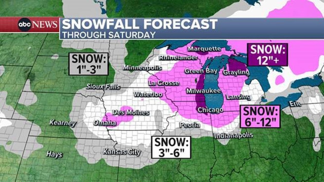
Blizzard warnings are in effect for six states from Nebraska to Wisconsin, including the major cities of Des Moines, Iowa, and Green Bay, Wisconsin. Strong winds are expected to accompany the snow, creating whiteout conditions, Snowfall could range from 6 to 12 inches.
In Illinois, roads are already covered with snow and visibility is poor. The National Weather Service in Chicago asked drivers to consider postponing their travel Friday morning.
A ground stop was issued at Chicago O’Hare International Airport Friday morning due to snow and ice.
Chicago O’Hare has canceled at least 25% of its Friday flights so far.
In the South, the same storm system is producing severe weather such as damaging winds, tornadoes and large hail from Texas to the Carolinas.
On Friday, severe weather is forecast from Mississippi to North Carolina with the bull’s-eye for damaging winds in northern Mississippi, from Jackson to Tupelo.
Tornadoes are possible in Mississippi, Alabama, Tennessee, Florida, Georgia, South Carolina and North Carolina.
The storm will move into the Northeast on Friday night, bringing heavy rain and strong winds. Flood watches have been issued from North Carolina to Massachusetts, where local rainfall amounts of 1 to 3 inches is possible within a short period of time.
Rivers remain swollen in the Northeast from recent rainfall, so the incoming downpour will only prolong flooding issues. New Jersey’s Passaic River reached its crest on Thursday night in the major flood stage. Due to the additional rainfall, the river is forecast to stay in the major flood stage over the weekend and possibly into early next week.
A potentially record-breaking cold blast is moving in behind this storm. Up to 100 record-low temperatures are forecast from the Pacific Northwest to the Gulf Coast this weekend and into next week. The National Weather Service has already issued wind chill alerts for 17 states from Washington to Texas.
In Montana, wind chills — what temperature it feels like — could reach 50s and 60s below zero, during which frostbite could occur in less than five minutes.
Kansas City, Missouri, and Chicago could see temperatures below zero on Sunday, Monday and Tuesday.
The coldest air will reach the Gulf Coast from Texas to Louisiana by Sunday into Monday and will last into Tuesday.
Another storm system is expected to sweep across the country this weekend into early next week with snow and ice possible for the South, from Texas to Tennessee.
This storm is forecast to move into the West on Saturday, bringing heavy snow to the Cascades and northern Sierra mountain ranges, before reaching the Rockies on Sunday, where snowfall amounts could get up to 2 feet.
By Sunday night into Monday, the storm will move into the Deep South with freezing rain and a wintry mix possible for parts of Texas, from Dallas to San Antonio and just north of Houston.
The storm will move into the rest of the South on Monday afternoon and evening with snow and ice possible in Louisiana, Mississippi, Alabama and Georgia.
Copyright © 2024, ABC Audio. All rights reserved.

