


(NEW YORK) — A massive volcano eruption in Iceland has triggered a warning from government officials that toxic gas is venting from a 2 1/2-mile-long fissure, but earlier predictions that the pollution could reach the capital have dissipated.
Growing fears of the toxic plume on the Reykjanes Peninsula where the volcanic activity is occurring prompted the Icelandic Meteorological Office to closely monitor wind directions and measurements of potentially dangerous particles spreading across the region.
Christopher Ham, a volcanologist at the University of Arizona, told ABC News that volcanic gas likely contains “a lot of very toxic material, especially sulfur.”
“Locally, it could be very dangerous,” Ham said.
The Meteorological Office warned Tuesday afternoon that “gas pollution might be noticeable in Vestmannaeyjar,” an archipelago off Iceland’s south coast. Officials had also said the gas pollution might reach Reykjavik, the capital city of more than 140,000 residents about 40 miles from where the volcano erupted.
In an updated statement Wednesday, the Meteorological Office said a change in wind direction could spare Reykjavik from the gas.
“Wind will turn northwesterly tonight and tomorrow, and pollution will be transported southeastward and out to sea,” the Meteorological Office said.
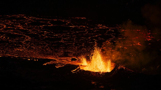
A volcano erupted Monday night in the Fagradalsfjall volcanic system and was accompanied by hundreds of earthquakes across the magma flow on the country’s southwestern coast.
The volcanic activity in Sundhnúksgígar on the Reykjanes Peninsula appeared to be diminishing Wednesday, according to the Meteorological Office. New aerial images analyzed Wednesday showed that “currently two craters are erupting,” down from five at the start of the event, officials said.
“The most active today is the crater directly east of Sýlingarfell, which is the southernmost of the craters that were active yesterday,” the Meteorological Office said Wednesday. “Lava continues to mostly flow east from the volcanic vents, but the lava tongue has also run west, north of Stóra-Skógfell.”
The southernmost edge of the lava flow did not appear to be advancing on Wednesday, officials said.
Satellite images taken Tuesday night showed that the lava field is about 3.7 square kilometers in size, or about 1.4 square miles, authorities said.
At least 320 earthquakes, one measuring a magnitude 4.1, have occurred since the volcano blew Monday night, the Meteorological Office said Tuesday. But since the eruption, seismic activity in the area has “significantly decreased,” officials said.
“There has been a significant decrease in earthquake activity, and over the last 24 hours, about 80 small tremors have been measured over the magma conduits,” the Meteorological Office said Wednesday, adding that the largest tremor struck at about 10:55 a.m. local time on Tuesday and measured 2.2 in magnitude, and the largest since midnight Wednesday was a magnitude 1.2 quake.
But danger is still lurking in the area, with an increased likelihood that more vents may open along the original fissure, as well as further north or south, officials said.
Following the volcanic eruption, the land around the Svartsengi power station, a geothermal power plant, sank about 5 centimeters, or about 2 inches, officials said. Before the eruption, the land had risen by about 35 centimeters, or roughly 14 inches, due to the magma channel that had been building since Nov. 10.
“It is too early to determine if magma will continue to accumulate under Svartsengi and whether the land will start to rise again,” the Meteorological Office said Tuesday.
Copyright © 2023, ABC Audio. All rights reserved.

